 |
HONG KONG HIKERS CLUB |
Welcome to the Hong Kong Hikers Club!
This is the place to meet likeminded people having fun to enjoy the hundreds of trails of Hong Kong.
Another great beautiful Hong Kong hike.
this time we went to Kai Kung Leng….also known in English as Rooster Ridge.
Difficulty: 8/10
I would not recommend this hike in the summer months. The sun can be brutal!!
There are no refreshment stops or supplied along the way so you need to bring everything with you…..lots of fluids and snacks.
Getting there:
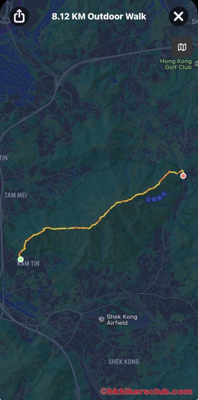
We went to the Kam Sheung Road MTR station. Exit C Public transport Interchange. Walk to the taxi stand and take a taxi to Fung Kat Heung road and the beginning of the trail. You can find the trail start on google map and show the taxi driver as we did. It’s hit and miss if the driver knows exactly where the trail starts. It cost about $56 HKD from the MTR station.
The Kai Kung Leng hike is a steep climb on a grassy mountain ridge in Lam Tsuen Country Park in northern New Territories.
Although not a long hike, it’s still fairly difficult due to steep and slippery trail conditions. Also the sun exposure on the hike is intense so virtually no shade.
Hiking the Kai Kung Leng trail from west to east as we did, you begin by climbing up steep, old stairs. Then, the trail turns into a dirt path which leads you over several peaks on your way to the top. After conquering the tallest peak on the ridgeline, its a steep, slippery descent to the other end of the trail.
Once you get to the ridgeline, be sure to look behind you to appreciate the views back towards Yuen Long. The wetland areas of the Nam Sang Wai fishponds offer a different kind of scenery than you usually find in Hong Kong.
Next up on the Rooster Ridge Trail, you’ll face a series of steep, rocky climbs. Honestly, the photos don't do justice to the steepness of the trail.
However, then you'll see that there’s actually one more peak to go. Kai Kung Leng has two peaks that are almost the same height. The first peak is 572 m / 1,877 ft. The second peak is 585 m / 1,919 ft, which is the highest point in Lam Tsuen Country Park.
Getting down towards Fanling is a challenge in itself. It’s is very steep and the trail is mostly rocky and can be quite slippery. Loose rocks, dirt and very uneven footing so please wear good shoes for hiking. This can be considered a hike for experienced people so have good equipment.
We ended on Fan Kam road. From there you can either get the bus, taxi or Uber. We saw plenty of taxis passing us by. We took an uber to the Fanling MTR. About 10-15 min drive.
Waypoints
| Label | Name |
|---|---|
| A | Fung Kat Heung Road |
| B | Kai Kung Shan |
| C | Kai Keng (308m) |
| D | Lung Tam Shan (550m) |
| E | Fan Kam Road |